
Capitol Reef is right next door; only 3 miles from us. Boulder Mountain, Thousand Lake Mountain, The Grand Staircase-Escalante National Monument, Lake Powell, and Goblin Valley State Park are all within easy reach. Capitol Reef is in the middle of the tour of Utah's "Mighty 5" National Parks (Zion, Bryce Canyon, Arches, Canyonlands, and Capitol Reef). So there's no shortage of things to see and do around here.
But in case you need some help getting started, we've put together some information for you. See our suggestions below:
See our Rates Contact Us Our Location
Capitol Reef National Park is one of the undiscovered gems of the National Park system. From May to September, the park offers a variety of ranger-guided programs at no charge. These include guided walks, talks, and evening programs at the campground amphitheater.
Hikes may take you deep into a narrow gorge, to the top of high cliffs for a bird’s eye view of the surrounding area, under a natural stone arch, to historic inscriptions... and much, much more! Round trip distances vary in length from less than 1/4 mile to 10 miles. All trails are well-marked with signs at the trailhead and at trail junctions and by cairns (stacks of rocks) along the way.
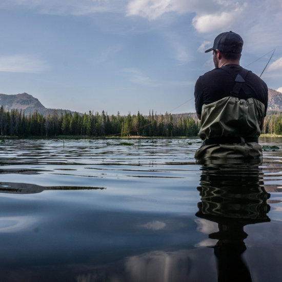
Fishing is permitted in the Fremont River with a valid Utah fishing license.

The funny thing about Thousand Lake Mountain is there aren't actually very many lakes there. Local lore has it that a cartographer mixed up the names of Thousand Lake Mountain and nearby Boulder Mountain on the first maps of the area and the mistake was never corrected. So don’t be let down by the name when you visit, but do check out this scenic, off-the-beaten path destination. You can drive Thousand Lake Mountain Road, a 35-mile scenic backway, from Fremont all the way through the Cathedral Valley section of Capitol Reef National Park. Once you descend into the Reef, a high-clearance vehicle is recommended. The jaunt takes you through alpine forests, around craggy cliffs, and past panoramic view points. If you only have a passenger vehicle, depending on the weather, you should be able to make it to the Deep Creek Desert overlook just past Snow Lake. Along the way, there are lakes and two-tracks for exploring as well as plenty of scenery.

The Grand Staircase-Escalante National Monument is a vast stretch of desert. The area is mostly white-sandstone mesa with some pretty incredible views, as well as some steep drop-offs. Some of the best attractions in the Grand Staircase are the Burr Trail (which will lead you back to Capitol Reef National Park) and Calf Creek Falls. You can hike, wade, and swim on both the Lower and Upper Calf Creek trails. When driving through the Grand Staircase, get gas and supplies at the towns of Boulder and Escalante.

The east slope of Boulder Mountain’s forested plateau overlooks the rugged cliffs and canyons of Capitol Reef National Park. Other stunning scenic vistas include The Escalante River from the south slope, Box Death Hollow wilderness area to the south, and Powell Point to the southwest. As part of Dixie National Forest, Boulder Mountain has about 60 high-elevation fishable lakes. While many of the lakes are tiny or run as stocked fisheries, trophy-size trout are not uncommon in the larger lakes, creeks, and streams. Although the high elevation lends itself to deep snow and cold temperatures, Boulder Mountain offers a long fishing season compared to Utah’s other high elevation mountains. The largest lake on Boulder Mountain is the 52-acre Blind Lake which offers excellent trout fishing and has a depth of 52 feet. Smaller fishing spots include Boulder Creek, Calf Creek, Sand Creek and Pine Creek.
Fishlake National Forest is named after Fish Lake, the largest (and possibly the best) freshwater lake in Utah. Fish Lake is an angler's paradise. It's famous for its large lake trout, rainbow trout, and splake. If you are visiting Southern Utah with your tackle box, then Fish Lake is a necessary stop. But even if you're not into fishing, there's plenty to see and do in Fishlake National Forest. Ride the many ATV trails, go hiking, break out the boats and the snowmobiles – there's no shortage of fun to be had. And every autumn, the aspens of Fishlake National Forest become a breathtaking golden color.
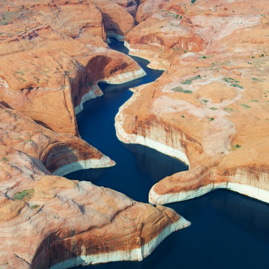
The town of Hanksville offers easy access to sparkling Lake Powell, where boaters, water sport enthusiasts and vacationers will find unrivaled beauty and endless recreation opportunities. Lake Powell is part of the Glen Canyon National Recreation Area that stretches from Canyonlands National Park (on the north) to the Marble Canyon (on the south). With it's many inlets and finger canyons Lake Powell offers nearly 2,000 miles of coastline. Of the six marinas around the 186-mile lake, Hite and Bullfrog Marina are the two most accessible from Hanksville. Hite, at the northern end of the lake, can be reached via UT-95 from Hanksville. Hite offers primitive camping, a gas station and a convenience store but boat access is limited due to low water levels.

While not as famous as the national parks, Utah does have an impressive collection of state parks. One of the best of these is Goblin Valley State Park. The park has a similar geology to Bryce Canyon, with an amphitheater of hoodoos being the main attraction. Goblin Valley is a great place in which to play games, chase the family around, and scrabble among the hoodoos. And don't forget to check out nearby Little Wild Horse Canyon – one of the best slot canyons in Southern Utah. Goblin Valley State Park is located in the San Rafael Swell, north of Hanskville. Get gas and supplies there.


Encompassing approximately 36,000 acres Bryce Canyon, is actually a series of fourteen amphitheaters that run in a north-south direction along the southeastern edge of the Paunsagunt Plateau for a distance of approximately 20 miles. The largest of the rock amphitheaters, Bryce Amphitheater, is 12 miles long, 3 miles wide, and 800 feet deep. On top of the plateau Bryce Canyon begins in elevation at approximately 8,000 feet and rises to just over 9,000 feet. East of the plateau is the Paria River Valley and in the distance various formations can be seen such as Powell Point, Navajo Mountain and the Kaiparowitz Plateau.
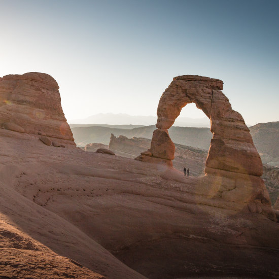
Arches National Park contains the largest concentration of natural arches and bridges in the world. The park is home to over 2,000 of them, including iconic Delicate Arch, the stunning Double Arch, and Landscape Arch – the fifth longest arch in the world. The park is relatively small, but is one of the most popular parks in Utah, so expect some crowds. The town of Moab is the main hub for people visiting the park, so be sure to stop there for supplies and gas.

The Maze Section of Canyonlands National Park is one of the most untamed and remote areas in all of Utah. This section of the park can be reached from Hanksville or Goblin Valley State Park via UT-24. Traveling north on UT-24, turn right onto the unpaved Lower San Rafael Road/County Road 1010 (the road is just shy of the turn-off to Goblin Valley State Park). A 48-mile drive along this isolated road will bring you to the Hans Flat Ranger Station, which is open year round.

Zion National Park is Utah's most famous park. Covering 146,597 acres of Southern Utah, it's the perfect collection of Southern Utah's best vistas. Zion Canyon is serviced during the peak tourist-season by shuttles, so you'll need to park at the main entrance. Stop by the visitor center before heading up the canyon to get oriented and to grab a map. We recommend that you hike Emerald Pools, and, if you're up for it, Angel's Landing. Once you've explored all of Zion Canyon, don't forget to visit the Zion-Mount Carmel Tunnel and the Checkerboard Mesa. Kolob Canyon is also worth checking out, but must be accessed via Interstate-15, north of the park. There are plenty of amenities near Zion National Park, but the City of Saint George is the most common place to stop for gas and supplies.